KINGSTON – FACTS, FIGURES, AND ITEMS OF INTEREST
SIZE OF VILLAGE Approximately 200 dwellings and 391 inhabitants are listed in the Register of Electors (1998)
SIZE OF PARISH Long and narrow (about 5 miles long and only a few hundred yards wide in many places) and approx. 2 square miles in area; a parish map is displayed in the playing field.
LISTED BUILDINGS The parish contains 15 listed buildings:- Black Robin Public House, Rectory Cottage, St Giles Church, Little Court, Kingstone Court, Ileden Farmhouse, Marley Farmhouse, Railway Cottage, Whitelocks, Whitelocks Farmhouse, Alley Cottage, Westwood Farmhouse, Barn, Stables and Granary at Westwood Farm.
ST. GILES CHURCH Largely rebuilt in the 14th. century but nave and chancel walls are 12th. century or possibly Saxon; pulpit Jacobean or possibly Elizabethan; replaced Norman font; King-post roof etc.
BLACK ROBIN PUB Built in 18th. or early 19th. century and named after a local highway man who ended his days on a gallows on Barham Downs.
THE BARN The village hall, ‘The Barn’, given to the village in 1931, supports a number of business, social and cultural activities, e.g. meetings of the Parish Council, Village Society, Wives Club, Model Engineering, Keep Fit etc.
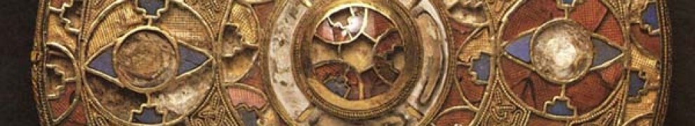
KINGSTON BROOCH One of the artefacts discovered in a Saxon burial mound above Kingston in the 1770’s was the Kingston brooch, of ornate gold inlaid with garnets, blue glass and white shell, and now kept at Liverpool museum.
RIVER NAILBOURNE Every few years the Nailbourne river runs through the parish; ‘bourn’ is the name for an intermittantly running stream. Its source is in Lyminge and it eventually joins the Little Stour beyond Wickhambreaux.
COVET LANE Running along the southern boundary of the parish, Covet Lane was the highest scoring of 200 lanes surveyed in the Canterbury area for landscape beauty, historic interest and variety of flora.
ELHAM VALLEY RAILWAY Closed in 1947. This ran between Canterbury and Folkestone through the parish. The arched railway bridge remains in Covet Lane as well as traces of the railway embankment. During the second world war, a 250 ton 18″ military gun, called the ‘Boche Buster’ was hidden in neighbouring Bourne Park tunnel and was to be used in the event of an invasion.
TWINNING Kingston is one of 7 villages in the Elham Valley collectively twinned with the Vallee de la Course, south of Boulogne, through the Elham Valley Twinning Association.
PUBLIC RIGHTS OF WAY The parish has about 8 miles of footpaths and bridleways, and includes sections of the North Downs Way and Elham Valley Walk. A set of 5 circular-walk cards is available and a map showing PROWS is located in the playing field.
BUS SERVICES Bus services to/from Canterbury and Folkestone/Dover stop in the village (bus shelter and Black Robin Pub, or on the A2 near junction to Ileden); time tables are available from Canterbury bus station.
HENRY MOORE The world renowned sculptor, Henry Moore, lived in a house on Marley Lane (now, The Orchard) during 1935-1940. In neighbouring Bishopsbourne, the novelist Joseph Conrad lived at Oswalds for 6 years before his death in 1924.
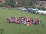
The Diamond Jubilee Celebrations of 4th June 2012 were a great success and a series of photos were taken of the attendees (click on a photo to enlarge):


I’m researching my family tree and cannot find any birth details for Augustine (Austin) Spain who married Ann Laurence on 12.10.1776. Can anybody help, please? The online marriage record doesn’t include parents – does the original?
Hi, I am also researching my Dine/Dyne family tree and I have noticed via ancestry.co.uk that there are postings of connections to the De Denne family as you have described. I too would like to know about the name change as I am left confused as to my lineage. My x4 g grandfather is John Dine 1821-1909 from Kingston and x5 g grandfather, his dad, John Dine b 1786 in Kingston etc. etc.
Any sharing of information would be greatfully received.
With Many thanks
Trisha Bridger
The last of the articles from the series re-published from the 1990 Village appraisal, this time a contribution from Tom Arter. Although over 20 years old now (and please bear in mind that some legislation may have changed since the article was originally written), it remains fascinating reading.
CONSERVATION
The word conservation is used to describe the protection of the environment, in the case of the parish of Kingston, both its natural and constructed environment. Straddling the Nailbourne Valley as it does, the south side contains the village area which is subject to a protection order covering most of the built-up areas of the Street and Church Lane, whilst the Northern area, basically open countryside, is protected as part of an area of outstanding natural beauty.
The Conservation area of the village, which came into force on June 6th 1979 under the Town and Country Planning Act of 1971, fairly tightly covers the built-up area of the village and prohibits the demolition of any building or structure without consent from the Canterbury City Council or the Secretary of State. It does not prohibit any development of housing as such, but apart from some limited infilling, building beyond the village envelope would seem unlikely as it would be contrary to the Kent Structure Plan.
Kingston has several listed buildings, including Westwood, Whitelocks, Kingston Court and Little Court. These buildings are subject to very strict planning regulations which prohibit any alterations to the character, both internally and externally. The Kent Structure Plan details the way in which open countryside in such an area can or cannot be developed and we already know developers who wish to build in such areas would normally have to go to appeal to get planning permission.
The area of Barham Downs is designated an area of Outstanding Natural Beauty. The main importance of this is to place the land included, under special protection against development which would destroy the character of the landscape. The public have no special rights in these areas as they are privately owned. However, this part of Barham Downs is crossed by the North Downs Way and several other footpaths, all of which are shown on the map on page 3. Although allowing rights of way, there are restrictions such as no picnicing, or the picking of plants or flowers which is an act of trespass. Farmers can, on the other hand, plough over a footpath if it crosses over established fields, although the right of way still exists and the field can be crossed; the farmer should reinstate the footpath within fourteen days.
Tree Preservation Orders (TPO’s) have been placed on a wide variety of trees from individually listed trees within the centre of the village to small shaves on the edges of the fields, especially in the Reed Farm area, and larger woodland areas such as Featherly and Quilters Woods on the western edges of the parish. All trees in the Conservation area of the village are protected as though they were the subject of Tree Preservation Orders. Dead or dying trees may be removed but it is the duty of the owner of the land to plant a replacement tree at the same place as the original unless the local authority dispenses with this requirement.
Featherly and Quilters Woods are classified as ancient woodland but can be classified as managed woods, with a mixture of tree species. TPO’s are required before coppicing can take place, known as coppicing with standards. The large trees (standards) are allowed to grow to considerable height over a period of perhaps a hundred years. Between the scattered standard trees are coppiced other trees and shrubs, most often hazel, sycamore or chestnut, which are cut in blocks on a rotational basis. This woodland management prolongs the life of these trees almost indefinitely, with some coppice stools being several hundreds of years old.
Obviously the Parish Council will continue to fight any developments on either a small or large scale, which would either increase the size of the village or lead to developments in open field areas. It is the compactness and size of the village which needs conserving and to this end considerable care needs to be taken in any further development allowed in the village. Whether it be low cost starter homes or larger commercial developments, Kingston should remain the quiet attractive village it has always been. If this can be achieved then the natural flora and fauna will also remain undisturbed and hopefully continue to flourish as it always has done.
Tom Arter
The following is the second of a series of articles from the 1990 village appraisal and was written by Margaret Smith
Prehistoric and Roman Times
The early pre-historic hunters of the Old Stone Age have left few traces of their presence, but the Neolithic farming culture, which arrived in this country about 4000 B.C. has left more evidence of its activities. Although there are no major Neolithic sites in this area, worked stone implements of the period have been found on the high ground in the west of the parish and also an axe-head from the late Bronze Age, about 900 B.C. Remains of the Celtic Iron Age culture are more numerous. The population had increased, and there are hill-forts and burial sites in many parts of the County, including Barham Downs. Evidence of Iron-Age occupation has been found near the A2 at Barham.
When Julius Caesar and his legions invaded Kent in 55 and 54 B.C., the region had recently been occupied by Belgic immigrants from Gaul and they still retained close links with their continental cousins. It was probably the influence of these people which led Caesar to comment that the natives of Kent were the most civilized in the country. The Romans adopted the Celtic name for the area, “Cantion”. This became Cantium and eventually, Kent, making it one of the few English place-names of pre- Roman origin. The only obvious Roman legacy to Kingston is the road they built across the Downs, which, as the major highway from Dover to London, has dominated the village ever since.
The Saxons
The first German settlers were mercenaries, employed to protect the coasts against Saxon raiders, after the Roman armies were withdrawn. According to legend, around 450 A.D. the British king invited Hengist, a war-leader of exceptional ability, to settle in Thanet with a band of followers. Hengist was not long content with this situation. He sent for many more followers (traditionally the early settlers of Kent were known as Jutes) and soon began his conquest of the county. By 488, when Oisc succeeded him as leader, the Kingdom was firmly established and Oisc founded the line of Kings which lasted for several centuries.
Jutish Kent was divided into large regions, each based on a central settlement, many of which were royal “vills”. These regions in a modified form, became the lathes of later history. One of the regions was based on the valley of the Little Stour (later part of the lathe of Canterbury, or Borowart) and included Kingston. Opinion is divided on the importance of Kingston in this region. One authority sees the valley being settled from the mouth of the river with Wickhambreaux as the main settlement, and Kingston a royal pasture-farm. This view certainly has much to recommend it, but on the other hand, the place name seems to have the meaning of “king’s manor”, there is a rich Jutish cemetery on the Downs, and there seems to have been a royal residence here in the early 11th century, when a marriage settlement between Godwine and Brihtric was made at Kingston in the presence of King Cnut, the Archbishop of Canterbury and the Abbot of St. Augustine’s, among others.
The Kentish kingdom reached the height of its power and wealth in the early 7th century (the period when the Kingston Brooch was made) but after 664 it began to decline. During the next 150 years, although it retained its own kings, Kent was more or less subordinate to Mercia. In 785 after prolonged rebellion, the Kingdom came under the direct rule of Offa and many of the leaders of the rebellion took refuge at the court of Charlemagne. One of these was Aldhun, reeve of Canterbury, who owned a small estate at Bishopsbourne. Before leaving the country he handed this estate to the Archbishop of Canterbury, but it was soon confiscated by Offa and given to one of his followers. Ten years later the people of Kent rebelled again, but in 798, according to Simeon of Durham “The King of the Mercians invaded the province of the people of Kent….and mightily devastated it with a grievous pillaging, almost to its utter destruction”. It is unlikely that Kingston escaped its share of the destruction. At about this time raids by Viking bands were also becoming more frequent, with coastal monasteries an early target and by 804 the nuns of Lyminge had taken refuge in Canterbury.
Domesday Book and the Middle Ages
Unfortunately Kingston does not appear in the Domesday Book and it seems that it may at this time have been closely linked with Barham. There is an entry in Domesday Monachorum which includes a list of churches making payment to Christchurch, Canterbury, [a document made about 1100] for “the other Barham” which is interpreted to mean Kingston. Barham was one of the large number of Kentish estates given after the conquest to Odo, Bishop of Bayeux, and was held from him by Fulbert de Dover. Fulbert also held Chilham and it seems that with the break-up of Odo’s estates, soon after Domesday, Kingston may have been part of the Barony of Chilham.
Sometime during the 11th century, the building of the church was begun. The walls of the nave and about two-thirds of the present chancel are thought to be original, the chancel being extended in the 13th century. The font is also said to date from the 13th century.
During the early middle ages, the landscape would have achieved much of its present form. It has been estimated that at least 8000 farm and hamlet sites in Kent have been occupied for 7 or 8 centuries and many for much longer – Palmstead is first recorded about 767 and Lynsore in 845. The climate in the early middle ages was better than at almost any time since and cultivation was pushed to its limits. Much of the local woodland shows ancient boundary features which may date from this time.
The manor of Kingston was granted in about 1312 to Bartholomew of Badlesmere, who shortly afterwards obtained the grant of a fair on the feast of St. Leonard. In 1340 the manor passed to Sir John Tiptoft and it must have been about this time that improvements were made to the church. The tower, most of the windows and the roof timbers are thought to date from the 14th century, and the oldest of the bells, recently removed, was cast in about 1350. Throughout the later middle ages, the manor passed from one family to another, because the owners died leaving only female heirs, until it was acquired in about 1460 by Sir Anthony Aucher of Bishopsbourne. Whether any of these owners were resident in the village is doubtful, but manorial courts were held until the 18th century, presumably at Kingston Court, near the church. The manor in this case was a land-holding, with the right to hold manorial courts and receive various payments from the tenants. It seems that no manor house ever existed in the village.
Barham Downs, above the village, has always been an assembly point for armies when invasions from France are expected. King John is said to have camped there with a large army in 1213, and during the Barons Wars against Henry III Simon de Montfort gathered his army there to oppose the landing of Queen Eleanor. With all the interaction, both war-like and friendly, between medieval England and Europe, there must have been a great many regal and other progresses along the Dover Road.
Tudor and early Stuart times
In 1558 with the beginning of the parish registers, the ordinary people of the village begin to emerge a little from obscurity, even if, to begin with, they are only names. Some of the earliest memorials in the church date from about this time, to John Nethersole, 1546 and Robert Denne, 1594. In 1511 it was noted by the authorities that the church lacked a gradual, an antiphoner, a surplice and a rochet, which the church-wardens were ordered to provide, but the fabric of the building was apparently satisfactory.
There was much excitement on the 10th May 1625 when King Charles I and his new Queen, Henrietta Maria, on their wedding journey from Dover, held a reception on Barham Downs “where were assembled all the English Nobilitie, and many Ladies of Honour….ranckt according to the dlgnitie of their great places and the Knight Marshall…keeping the vulgar from intruding”. One observer thought that “the Country-Ladies outshined the Courtiers” and another added that there were pavilions and a banquet prepared.
The Civil War
Kent was in the hands of Parliament from the beginning of the Civil War, so all the major battles took place far away, although there were continual plots and rebellions, stirred up by the royalist element in the county.
The leaders of Kentish society were mainly members of old county families, moderate in their opinions but very independent minded. This is well illustrated by Sir Thomas Wilsford of Ileden who shortly before the Civil War, led his men to join the King’s army against the Scottish Covenanters. Sir Thomas approached the King and said “I pray God send us well to do in this business, but I like not the beginning….because you go the wrong way to work”. When the King smiled and asked him which was the right way, Sir Thomas told him that he should go back and call a parliament to raise money for the war.
Despite such feelings, the Wilsfords remained royalists and the third son, Edward, fought with the King’s army and was wounded at the battle of Worcester. However, Sir Thomas’ wife Elizabeth was the half-sister of Edwin Sandys of Northboume who was a colonel in the parliamentary army. Sir Anthony Aucher of Bishopsbourne, who was also Lord of the Manor of Kingston, was an active royalist. It was not until 1648 when the Civil War had been over for two years, that Kingston saw action. The harsh suppression of a riot in Canterbury and the general discontent with the activities of the ruling County Committee led to the organization of a petition to Parliament and then to county-wide rebellion. The revolt was soon suppressed by parliamentary forces under Sir Thomas Fairfax, but in the course of it, there is said to have been a skirmish between the two sides at Kingston, when every building was occupied, even the church. Sir Anthony Aucher, who played a prominent part in the rebellion, fled to Holland, having already disposed of his Kingston property the previous year, although he retained his Bishopsbourne estate.
The Rector of Kingston during the Commonwealth was Nicholas Dingley, who was appointed about 1647 and was probably to some degree a puritan. He seems to have been resident hi the parish, as his children were baptized there, and he must have suited most of the parishioners, because at the Restoration there was an unsuccessful attempt to eject him from the living and replace him with one Miles Bames, who was well connected with the local gentry. However, Mr, Dingley continued in office until his death in 1672.
The Hearth Tax returns for 1664 list 47 householders including both Mr. Dingley and Mr Bames, while a religious census, taken in 1676 lists 221 inhabitants, with no papists and five protestant non-conformists.
The 18th and 19th Centuries
Little is known about the highwayman, Black Robin, who gave his name to the village public house except that he operated on the Dover Road and is said to have been a fairly vicious character, shooting those who offered any resistance. His exploits must have taken place during the first half of the 18th century, as Black Robin Corner appears on a map of 1769 and there was a licensed ale-house at that address in 1756.
For almost 200 years, from about 1700, there was a race-course on the Downs above Bishopsboume. Originally it extended from the front of Highland Court to Ileden, but about 1770 it was made shorter and rounder, so that in a four mile race the runners passed the grandstand twice. Cock-fighting also took place every day during the races. Racing on Barham Downs finally ended in 1879 and afterwards some of the area was turned into a golf- course.
In 1750 Bryan Faussett became curate of Kingston. (The incumbent, Peter Innes, was at this time about 60 and probably in ill health). Faussett was an antiquarian and became interested in the barrows on the Downs above Kingston, but he was not able to set to work on them until 1767, because the owner of the land refused his permission. However, after his death, the land passed to the Rev’d William Dejovas Byrche, whom Faussett describes as “my very worthy and learned friend”. Over the next few years he excavated numerous graves, numbering them and recording his finds in a manner which was very scientific for his time. His most famous find was the Kingston Brooch, a large and splendid example of early 7th century Kentish jewellery, now in a Liverpool museum. Faussett made another more parochial contribution to village history, when he rescued the 13th century font, which had been damaged and discarded from the Church and was apparently being used as an animal feeding trough. He took it to his home near Canterbury, where it remained until it was restored and returned to Kingston Church in 1931.
At the end of the 18th century, with war and revolution just across the Channel, the Downs were once again in use as a military encampment. Between 1799 and 1804 several baptisms took place in St. Giles Church of soldiers” children “from the camp”.
With the ending of the Napoleonic Wars in 1815, the position of the agricultural labourers became very difficult Unemployment and starvation-level wages, combined with rising prices and the effects of archaic poor-laws culminated in 1830 in riots, which began in East Kent and spread to other parts of the country. The labourers realised that the new threshing machines would deprive them of what little work there was during the winter, and they set about destroying them. Some of these disturbances took place in the parishes around Kingston. Mr. John Sankey of Digges Place was awoken by a crowd of about 200 men entering his yard, who proceeded to break up his threshing machine and throw the remains into the pond. Marley Farm is reputed to have been the scene of another battle.
The affairs of the village at this time were to some extent still in the hands of the various parish officers, although they were gradually losing their old powers. The Road Surveyor, for instance, had to obtain materials for repairing the roads, find men to do the work (usually reluctantly) and keep accounts of the money paid out. Twice a year he had to go to Wingham “to sware to the accounts”. In 1846 the Surveyor was instructed “to dissent from all the plans of the different Railway Companies sent to him”.
In 1836, an Act of Parliament was passed commuting the hated Tithes in kind to a fixed charge. In order to carry out this measure, over the next few years detailed maps were made of most parishes with lists of all the owners and occupiers of the land. Kingston was surveyed in 1839 when the 1540 acres of the parish consisted of 1141 acres of arable, 246 acres of meadow or pasture, 19 acres of hops and 134 acres of woodland.
The commutation of the tithes was part of the great wave of reforms taking place at that time in both Church and State. It may have been this wind of reform which blew through Kingston Church in 1846, when it was thoroughly restored by the Rector, parishioners and landowners. Among other work, the tower was repaired, the gallery and chancel screen were removed, a new floor laid and new pews put in and all was cleaned and redecorated. To pay for the pews, the parish had to borrow £100 which was paid off in four yearly instalments. The churchwarden’s accounts for 1846 include “carriage of benches from Dover 8/-” and “carriage of sand and timber for tower 12/-“.
Despite all the objections of the parish officers of 40 years earlier, the railway eventually came to Kingston in 1887. Work began on the Elham Valley Railway at the Folkestone end in 1884 and the final stage to Canterbury was completed in 1889. Most of the landowners on the route were reluctant to sell to the company, but the strongest objections came from Matthew Bell of Bourne Park, whose house lay only 200 yards from the proposed route. After protracted negotiations it was agreed that the line should pass through a deep cutting and a tunnel to the rear of Bourne Park. There was never a station at Kingston – villagers wishing for a day out in Folkestone or Canterbury had to walk to Barham or Bishopsbourne stations.
The 20th Century
30 years later, during the first World War, the railway was used to help transport the injured men coming back from France. A local farmer, who was a boy at the time, has told of climbing into a tree near the line and seeing the trains full of wounded pass through. Another farmer had a field commandeered one evening to pasture about 100 horses on their way to France. We know the names of the 6 village men who died in the Great War, because their names are inscribed on a tablet in the Church, but many others also went to fight, leaving their families at home to cope. Miss Mary Pettit, for instance, at the age of 18, took over the running of Little Marley Farm when her brother went to war and her father became unfit to work. After the War the land was divided between the two of them and she continued to farm her share until she was 75, and for many years she was the only woman regularly dealing at Canterbury market.
The years between the wars in Kingston have been chronicled by the Rector of the time, Canon Potts, in his parish magazine. Quite a number of new houses were built, the Barn was converted and given to the village by Canon Potts and his sister, and George V’s Jubilee was celebrated jointly with Barham, with a procession, tea, games and a bonfire. Kingston contributed between £90 and £100 towards the building of the new Kent & Canterbury Hospital, there was death-watch beetle in the Church roof and, after some delay, the electricity came in 1937. Canon Potts retired in October 1939 just after the outbreak of World War Two.
Kent was then once again the front line, with preparations for invasion, the Battle of Britain being fought overhead, and later, the “doodlebugs” falling out of the sky. Perhaps the strangest episode as far as this area was concerned was the siting in Bourne Park railway tunnel of the huge gun, nicknamed the Boche Buster. It had an 18″ barrel, weighed 250 tons and its shells were 6ft 7ins long. The direction and curve of the railway line at Bishopsbourne and Kingston meant that by moving to different points, the gun could cover much of the Channel. The Boche Buster was tested on 13th February 1941, when several rounds were fired from the stretch of track near the Black Robin. Villagers had been warned to open doors and windows, but the blasts still caused some damage. The gun was only fired a few more times, but it did receive a visit later in the year from Winston Churchill, who came to inspect it at Bishopsbourne station.
After the war, village life carried on much as it had been for a few years, until in the early 1960s, the building of more new houses, particularly the three closes, led to the village as we know it today.
The following article is reproduced from the 1990 Village Appraisal by Charles Fagg.
ENVIRONMENT OF KINGSTON
General
The Parish of Kingston is long and narrow, being approximately five miles long and in many places only a few hundred yards wide, running roughly NE-SW and containing about 1,250 acres (500 hectares) or nearly two square miles. It consists of a series of valleys and ridges, vary¬ing between 120 and 450 feet above sea level, with the village built at the junction of the Nailbourne and Covert valleys. Kingston is on the eastern edge of the ‘North Downs Area of Oustanding Natural Beauty’ and the underlying chalk, which extends to approximately sea level, is the main factor influencing the environment of the parish, both in the nature of the countryside and of the flora and fauna living here.
Geology
In the east of the parish, the north-south ridge of the open chalk of the Barham Downs slopes down to the Nailbourne valley, with only a very thin covering of light chalky soil. The Nailbourne is an intermittent stream which runs south-north through a relatively narrow flood-plain of light, almost peaty soil, overlying a bed of very coarse gravel. The Nailbourne, traditionally appearing only every seven years, but in practice rising anything between one and ten years, only runs for a few months at a time, always during the winter. Like its frequency the flow can vary enormously from a mere trickle, to, as in 1988, a torrent of more than 2 million gallons an hour. At full flow the whole of the flood-plain is either flooded or severely waterlogged.
To the west of this valley the land rises gently, forming a ridge of deep fertile loam upon which the main part of the village is built. Further up the ridge the chalk again comes to the surface, with a thin loamy topsoil. The shallow valley to the north of this ridge is again a downland type of soil, whilst the southern boundary of the parish follows the line of the Covert valley. This valley has almost no ‘floor’, the chalk slopes extending nearly to the valley bottom. As you go west along this valley, the slopes get progressively steeper and less fertile, until towards the south-western end of the parish it is almost solid chalk with only the thinnest of soils. On the higher ground to the west of the village the loam gives way to a layer of very heavy red clay with flint, known locally as ‘clyte’, which outcrops along the edge of the plateau. This clay or ‘marl’ gives its name to Marley Lane and although fairly fertile, is very difficult to work. On the plateau which forms much of the western part of the parish, the soil is a lighter, free-draining loam, still with flints, overlying several feet of brick-earth. Despite the chalk below, these hilltop soils tend to be acid, especially in some of the woods where the acidity seriously restricts plant types. Either side of this plateau the land falls away very steeply into the Covert and Pett valleys and in many places there is little soil over the chalk. Much of this area is covered by natural woodland, most of which is still coppiced at regular intervals. Some conifers were planted about 40 years ago but have gen¬erally not been very successful. A substantial area of well managed chestnut coppice occupies much of the flat hilltop at the extreme western end of the parish.
Agriculture
The farming is largely dictated by the soil types, although with modern systems the differ¬ences are not as great as they were in the past. Very little ancient grassland remains although some patches have not been ploughed for many years. The light, dry downland soils in the east and north of the parish face south and west and are reasonably warm. They are now largely arable, growing cereals, lucerne and short term grass, including grass for seed. The floor of the Nailbourne valley is also mostly arable and is a noted frost pocket. Despite this, handled with care, its light, fluffy, soil is capable of growing more demanding crops such as potatoes and maize. These crops also spread up on to the deep loam on the western side of the valley. With the steady growth of the village in recent years, much of the fertile ridge is now occupied by houses and gardens, but some pasture land remains, mainly on the southern side.
The heavy land above the chalk is also mostly arable, arable grass, or natural wood. Similar cropping is also to be found on the western plateau, but the lighter loam here encourages the growing of other crops such as potatoes, pulses, oilseed rape and root crops, although with the decrease in livestock numbers in recent years roots are becoming less common. Those parts of the steep valley sides which are not wooded are largely grassland, mainly grazed by sheep, but with some beef cattle. The numbers of farm animals based in the parish are now very low. There are signs that the number of beef cattle is rising but there have been no commercial dairy cattle or pig herds in the parish for several years. A lot of sheep are grazed, mostly from farms based outside the parish. There have been no heavy horses for many years, but the number of riding horses con¬tinues to rise steadily. A small group of driving ponies are kept on one smallholding.
The parish does not seem to have had a ‘big house’ and estate for a very long time, if ever, and as a result almost all the land is owner occupied, although much of it, particularly in the eastern half, is farmed by large farms based outside the parish. A number of independent small farms still exist in the western half, three of which have been formed in the last fifteen years as a result of the splitting up of larger holdings and the sale of land away from the no longer viable small farms of the past. Evidence in old deeds shows that this constant change in the size of the farms has been a feature of the area for a very long time. In addition to the commercial farms there are a considerable number of small-holdings, mostly around the village and along the Covert valley. These contain most of the older pastures in the parish and also many of the horses.
Rights of Way
The parish is well served by public Rights of Way. The busy A2, Canterbury to Dover trunk road, runs north-south across the top of the Barham Downs, whilst two lesser routes run the full east-west length of the parish. Starting at Ileden, in the extreme east of the parish, two footpaths cross the A2 and continue towards the village, one as Straight Hill, which is a bridle road, and the other as Black Robin Lane. These two routes continue westwards, passing north and south of the church and becoming The Street, and Covet Lane, respectively. At its western end The Street divides to become Marley Lane and Westwood Road. Roughly following the contours, these three roads run nearly parallel right to, and beyond the western end of the parish. From the North Downs Way (an official long distance path) in the east, to Turks Hill in the west, a total of four¬teen rights of way cross between these east-west routes. This total is made up of four public roads, four bridleways and six footpaths, many of which continue into the adjoining parishes.
There are more than a dozen footpaths shown on the Definitive Map, but the shape of the parish and the layout of the roads means that they tend to be short, at least within Kingston boundaries. The shortest, at about 50 yards each, are Faggs alley in the centre of the village and, in the west of the Parish, Chalky Bank, which joins Reeds Hill with the bridleway on the Parish boundary. The longest starts at Quilters Farm, passes along the southern side of Quilters Wood, and joins the road close to Clambercrown, a distance of about three quarters of a mile. The paths originally served the outlying farms and cottages linking them with each other and with the Church and pubs. A glance at the paths map will show how paths radiate from the village and from the main outlying settlements of Ileden, Marley and Westwood, often linking with others crossing between settlements in other parishes. Following the last war and with the increase in car ownership, many of these paths fell into disuse, and a number were officially closed. In recent years the demand for leisure walking, along with the ever increasing numbers of horses, has resulted in most of the remainder being re-opened and regularly used. Many of these paths provide direct links to our neighbouring villages, although nowadays relatively few people use them for that purpose. One exception is the bridleway between Kingston and Bishopsboume which is well used by walkers and riders. The majority of the Rights of Way in the parish are open and usable, although some are poorly marked. A few are still not open and need work to make them usable. It is hoped that a local footpaths group can be formed to undertake this work and to improve the maintenance and waymarking of all the paths. Some minor changes could be made to the system to make it more suitable for modern needs but these are virtually ruled out by the present laws.
Flora and Fauna
Even more than with the farming, the natural wildlife of the area is dictated by the soil on which it lives. Most of Kingston is on the very alkaline, chalk soils but some of the high ground is acid. This gives a great variation to the plant life. The open, almost treeless, downlands to the north and east of the village have lost most of their natural vegetation but a few small areas can still be found, particularly along the road verges and around the ancient earthworks east of the A2. This type of vegetation tends to be small and not very showy, although the bedstraws can make a splash of colour. Some of the larger thistles also find this situation to their liking. Along with more common downland plants, dewberries and wild parsnip can be found on the verges of Bonnybush Hill. The Nailbourne valley has few unusual plants, possibly due to its liability to flood¬ing in winter and drying out in summer. The early bright green of alexanders is now appearing near the river bed as is the rather aggressive hairy willowherb. Within the village, from the river bed westwards, more trees appear but it seems likely that most of these have originated from planted specimens.
The old railway line carries a very wide selection of native trees along with a number of plants such as eyebright and red bartsia which thrive on the dry, hard embankment. To the west of this embankment the natural chalk begins to have its influence with a number of thick scrubby hedges, composed largely of maple, hazel, blackthorn and hawthorn, dividing the fields. Wild roses also thrive round the outskirts of the village. Oaks prefer the heavier soils and in Charlton Wood we find a good example of the natural ‘coppice with standards’ type of woodland of which a considerable amount still remains on the high ground in the western half of the parish. The periodic coppicing (cutting) of the underwood produces a long-term rotation amongst the smaller plants of the woodland floor. As the underwood trees get taller and more smothering, most of the vegetation beneath them dies away leaving the way clear for plants such as anemones and bluebells which flower before the leaves appear on the trees. Primroses and some orchids also appear at this stage. Most of these flowers have bulbs, corms, or fleshy perennial roots. Following the felling of the trees large numbers of biennials and perennials germinate but it is the second spring before these flower. They include spurges, wood and bore thistles and in some places wild angelica, hogweed and the very showy rose bay willowherb. These strong growing plants quickly smother the smaller plants but in a year or two are themselves smothered by shrubs such as broom, blackberries and silver birch. By this time the ‘springs’ of the regrowing trees are several feet tall and after six or seven years will, in turn, be smothering the shrubs. As this happens the wood begins to open out again, the bluebells re-appear and the whole cycle starts again. Depend¬ing on the type of trees, a full cycle takes between 15 and 40 years with all the plants reappearing in their due order. Above all this the oak and ash standards slowly get bigger, until in due course they are harvested as timber, leaving smaller specimens for the future.
The open parts of the plateau support a very wide range of plants which tolerate the more acid conditions. On the arable fields the more aggressive spring flowering plants such as charlock, poppy, mayweed and thistles tend to become a problem and are often sprayed. Whilst this reduces their numbers, enough always survive to provide seed for the future. Many of the smaller, less showy species flower later in the summer and so avoid the sprays and continue to thrive. In places lime hating plants such as spurry and sorrel provide good indication of the acidity. On the steep valley sides the chalky conditions suit a huge range of flora, many of which are quite small. Several species of orchid, including the impressive lady orchid, occur in considerable numbers. The rare bee orchids can be found on at least two sites. Cowslips can also be found in small numbers on these slopes. With the exception of the common arable weeds, which are now not seen in such profusion as in former years, the numbers and locations of most of the wild flowers has changed very little over the last fifty years, and well over 150 species can be found in the par-ish. A similar situation exists amongst the birds. Whilst the numbers of some species such as the grey partridge and the sparrow hawk have declined, they are still seen. Others such as skylarks, missel thrushes and red-legged partridge have increased noticeably. More species are seen now than in former years but this may be due to more observers rather than more birds! Tree- creepers, nuthatches and hobby are amongst the rarer birds recently seen. Kestrels remain common whilst the numbers of owls, particularly bam owls, is rising steadily, partly due to the positive conserva¬tion now being practiced in the area. The long-eared owl and the tiny goldcrest are amongst newcomers attracted to the conifer woods. Whilst some are just passing visitors, a total of more than 120 species of bird have been seen in or over the parish in recent years. Whether it be due to changes in attitudes or the environment, there can be no doubt that the total population of birds has increased very noticeably over the last 50 years.
Because they are more rarely seen, it is more difficult to assess the situation with mammals. The biggest single influence for change was the advent of myxamatosis. This not only decimated the population of rabbits, but by changing the availability of food, affected many other species as well. Foxes, stoats and to some extent, weazels relied on rabbits for a large part of their diet. The loss of this major source of food not only reduced the population of the predators but probably also caused many more of the smaller animals to be caught, thus also reducing their numbers. Although myxamatosis has now become endemic, the number of rabbits has built up again in recent years and it is probable that the situation is now nearly back to normal. The numbers of foxes and badgers seen has increased considerably in recent years and there is some evidence to suggest that they are becoming less wary of man. At the other end of the size scale, the harvest mouse is now more commonly seen, perhaps due to the different harvesting time of modem cereal varieties.
Little is known about the insect population, either now or in the past. About 15 species of butterfly are still seen regularly, although some, such as the marbled white and white admiral are not as common as formerly, whilst the red admiral and orange tip are more common. Because many insects depend on just one species of plant to provide them with food it is likely that they will have suffered from environmental changes to a greater extent than those creatures which have a wider choice of food. Those areas of downland and near downland which still exist probably also still support small populations of most species of insects. Similarly, little is known about the huge numbers of fungi found in the area, especially in the woods, but there is no reason to think that there has been any major change.
It has become obvious that all aspects of the environment are closely linked. The building of houses destroys some habitats but well stocked gardens provide havens for many birds and insects. Modern farming practices harm some things but assist others by providing different habi¬tats. Fewer livestock has meant new hedges springing up along fence lines, thus more bird nesting sites. Most young birds are fed on insects or grubs, so more birds may mean fewer insects. Forestry changes have encouraged new species of birds and probably insects and fungi, but fewer flowers thrive under conifers than hardwoods. Changed laws have protected many flowers from many people. Less shooting has made life easier for birds such as magpies and jays, both of which play havoc with other birds’ eggs and young. No major changes can be seen on the horizon at the moment but no-one knows just what the future will hold. Hopefully the present moves towards both increased knowledge of, and better conservation of, the natural environment all around us are likely to decrease, rather than increase the rate of environmental change both in the parish and the area as a whole.